Search

Categories

    • categories-img Jacket, Women
    • categories-img Woolend Jacket
    • categories-img Western denim
    • categories-img Mini Dresss
    • categories-img Jacket, Women
    • categories-img Woolend Jacket
    • categories-img Western denim
    • categories-img Mini Dresss
    • categories-img Jacket, Women
    • categories-img Woolend Jacket
    • categories-img Western denim
    • categories-img Mini Dresss
    • categories-img Jacket, Women
    • categories-img Woolend Jacket
    • categories-img Western denim
    • categories-img Mini Dresss
    • categories-img Jacket, Women
    • categories-img Woolend Jacket
    • categories-img Western denim
    • categories-img Mini Dresss

Filter By Price

$
-
$

Dietary Needs

Top Rated Product

product-img product-img

Modern Chair

$165.00
product-img product-img

Plastic Chair

$165.00
product-img product-img

Design Rooms

$165.00

Brands

  • Wooden
  • Chair
  • Modern
  • Fabric
  • Shoulder
  • Winter
  • Accessories
  • Dress

Welcome and thank you for visiting us. For any query call us on 0799 626 359 or Email [email protected]

Offcanvas Menu Open

Shopping Cart

Africa largest book store

Sub Total:

Search for any Title

Collins Children’s World Wall Map : An Illustrated Poster for Your Wall

By: Collins Kids (Author) , Steve Evans (Illustrated by)

45 in stock

Ksh 2,200.00

Format: Sheet Map, Rolled

ISBN-10: 0008319790

ISBN-13: 9780008319793

Edition statement: 2 Revised edition

Publisher: HarperCollins Publishers

Imprint: Collins

Country of Manufacture: MY

Country of Publication: GB

Publication Date: May 16th, 2019

Publication Status: Active

Product extent: 1 Pages

Weight: 96.00 grams

Dimensions (height x width x thickness): 91.70 x 3.00 x 3.00 cms

Product Classification / Subject(s): Educational: Geography
Atlases & maps (Children’s/Teenage)

Choose your Location

Shipping & Delivery

Door Delivery

Delivery fee

Delivery in 10 to 14 days

  • Description

  • Reviews

Beautifully illustrated wall map for inquisitive kids Colourful Illustrated Map of the World
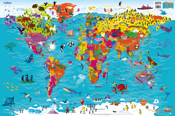
Beautifully illustrated wall map for inquisitive kidsColourful Illustrated Map of the WorldThis bestselling, highly illustrated pictorial map is designed to take children on a journey of discovery around the countries of the world. The mapping is up-to-date, colourful and highly informative and shows countries and capital cities.Stunning illustrations are used to depict themes such as national emblems, customs, food, birds, animals, buildings and sports to help younger readers gain an understanding of the world.Dimensions 610 X 915 mm / 24 x 36 inchesIllustrated by Steve Evans.Now with barcode removed due to popular demand from our customers.

Get Collins Children’s World Wall Map by at the best price and quality guranteed only at Werezi Africa largest book ecommerce store. The book was published by HarperCollins Publishers and it has pages. Enjoy Shopping Best Offers & Deals on books Online from Werezi - Receive at your doorstep - Fast Delivery - Secure mode of Payment

Customer Reviews

Based on 0 reviews

Mind, Body, & Spirit